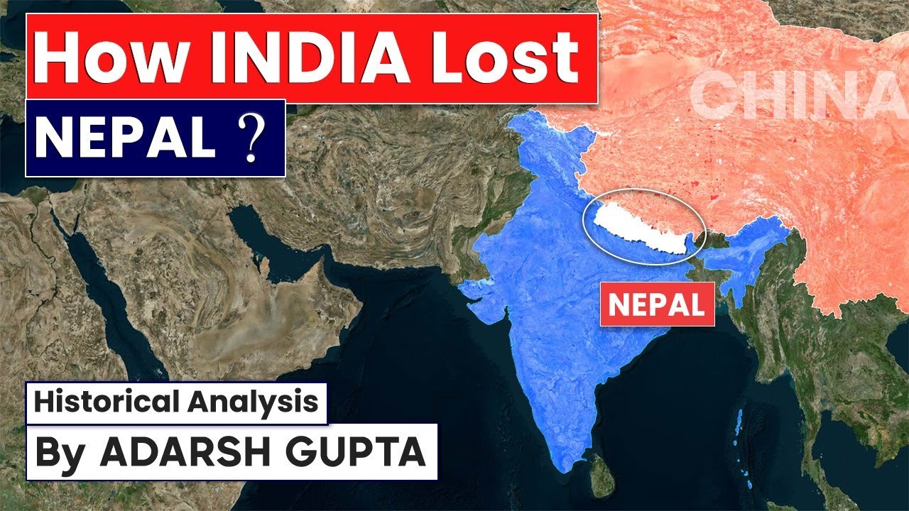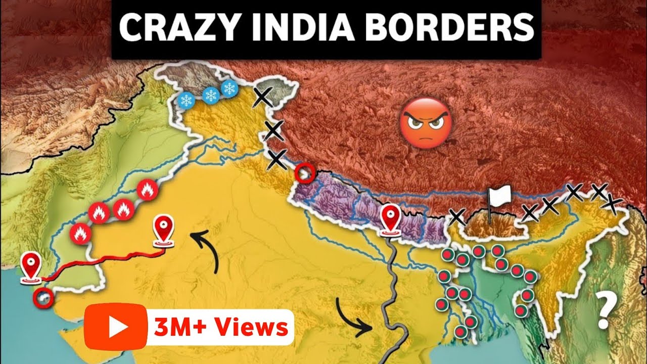

The India-Nepal border serves as an essential boundary line that stretches across a massive physical distance, linking five Indian states through an open and highly porous border. Gaining clarity on this geographical boundary alongside historic disputed territories like Kalapani and Susta is crucial for students reviewing geography and international relations. It offers vital context regarding South Asian geopolitics and the foundational Treaty of Sugauli signed in .
🎯 In this chapter, you will understand:
- The geographical layout and porous nature of the open border between India and Nepal.
- The five Indian states that share a direct boundary with Nepal.
- The historical background of the Kalapani territorial dispute and the role of the Kali River.
- How changes in the course of the Gandak River created the boundary dispute in Susta.
💡 Why this topic matters: It forms a core pillar of South Asian geopolitics and features regularly in competitive examination syllabi such as the UPSC.
🧠 Core Idea: Natural riverine shifts and varying interpretations of colonial-era treaties continue to shape border dynamics between India and Nepal.
Geographical Boundary, Bordering States, and Disputed Territories Between India and Nepal
The long boundary connecting India and Nepal stands as a active geographical feature that carries immense historical significance and strategic value.
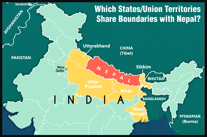
Running primarily along the foothills of the Himalayas, this shared boundary encourages unique social, economic, and security ties between both neighboring countries.
- (i) A major characteristic of this border is its porous nature, which allows people and goods to move freely without strict restrictions.
- (ii) Five Indian states directly touch this strategic frontier: Uttarakhand, Uttar Pradesh, Bihar, West Bengal, and Sikkim.
- (iii) Most of the international boundary runs from east to west, positioned right along the lower slopes of the Shiwalik Range.
Historical and Geographical Flashpoints: Key Border Disputes (Kalapani and Susta)
Even though the border remains largely peaceful and open, two main areas—Kalapani and Susta—continue to be points of disagreement. These issues stem from colonial-era agreements and natural shifts in river courses over time.
The Kalapani Region Territorial Claim and the Kali River Boundary
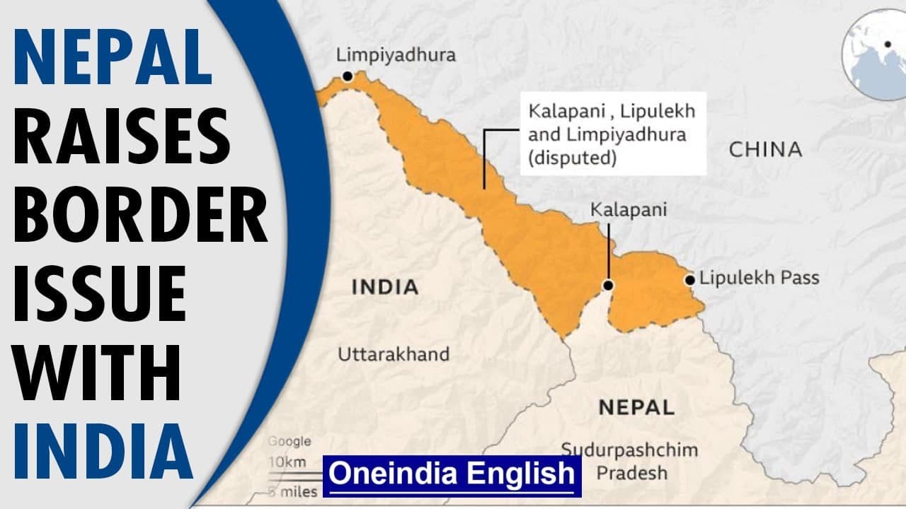
The Kalapani valley is an important piece of disputed land located along a key transit route. It has long been tied to how Nepal's western border was mapped. India currently controls and manages this area, but Nepal has repeatedly raised claims over it, especially after releasing updated official maps.
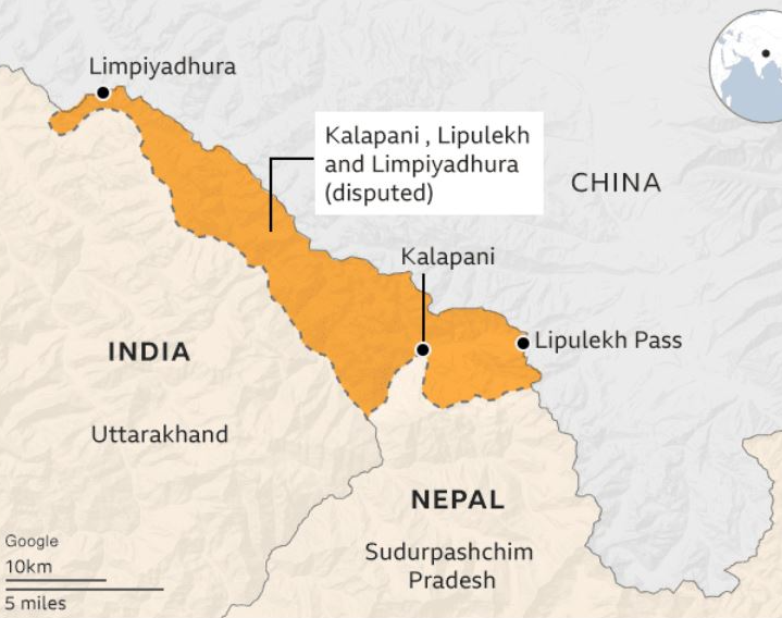
India-Nepal border disputes - (i) India manages the valley as a part of the Pithoragarh district in Uttarakhand, sitting right along the primary pathway toward Kailash Mansarovar.
- (ii) India maintains that this historic area is an essential part of Uttarakhand, a position recently reconfirmed in its official maps.
- (iii) The heart of the disagreement lies in where the boundary line actually sits, as it was originally marked using the Kali River in the Kalapani zone.
- (iv) The historic Treaty of Sugauli, signed in following the Anglo-Nepalese War, set the Kali River as the boundary for Nepal's western border with British India. However, differing views on where the river actually originates created the present-day dispute, leading both countries to publish maps that favor their own claims.
The Susta Region: Boundary Shifts Due to the Gandak River's Course
The disagreement over the Susta region illustrates how natural geographical changes—like a river shifting its path over time—can complicate international border agreements and lead to ongoing friction.
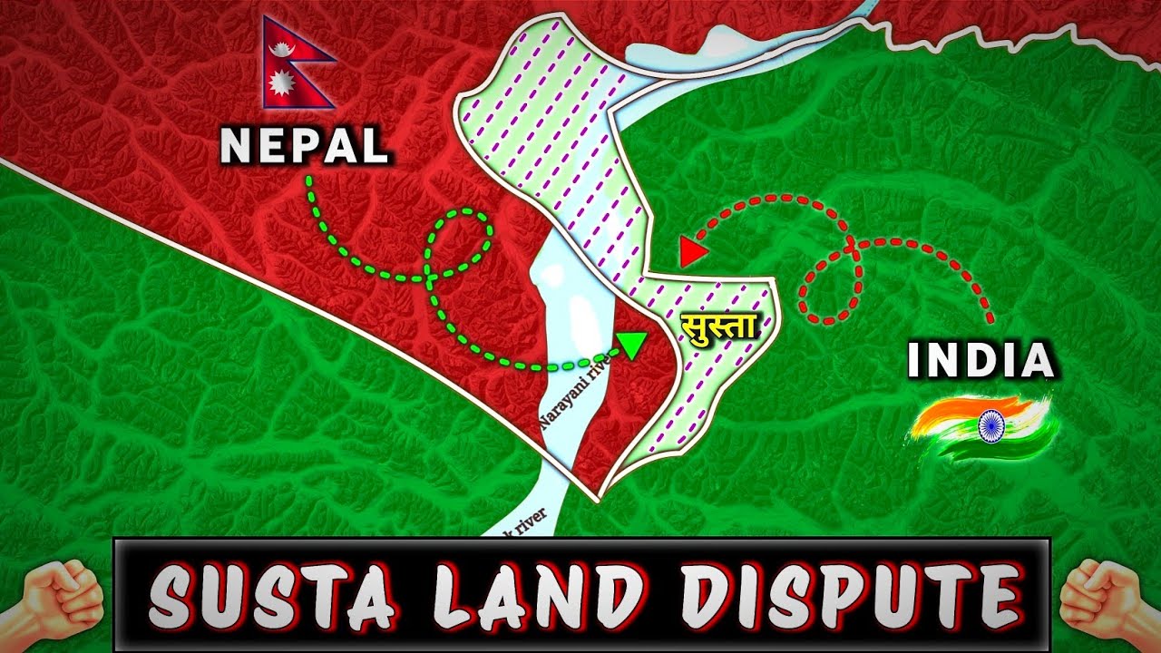
- (a) Susta is a disputed border area located between India (specifically Uttar Pradesh) and Nepal.
- (b) It is strategically located on the banks of the Gandak River, which is referred to locally as the Narayani River in Nepal.
- (c) The root cause of this long-standing disagreement in Susta is the gradual change in the course of the Gandak River over many years.
- (d) According to the original rules of the Treaty of Sugauli (1816), the Gandak River served as the official international boundary, where the western bank belonged to Nepal and the eastern bank belonged to India.
- (e) When the treaty was originally signed, Susta village was located on the western side of the river. Over time, as the Gandak River changed its path, the village ended up on the eastern bank—effectively placing it on the Indian side of the river and creating the ongoing territorial claim.
Conclusion: Geopolitical Importance of the India-Nepal Border for Students and UPSC Exams
The India-Nepal border, framed by the five adjacent states of Uttarakhand, Uttar Pradesh, Bihar, West Bengal, and Sikkim, is much more than a dividing line; it is a crucial political and geographical zone. Learning about the baseline set by the Treaty of Sugauli (1816) and understanding the details behind the Kalapani and Susta disputes caused by river pathways (the Kali River and Gandak River) is essential knowledge for students. This topic is especially important for candidates preparing for competitive tests like the UPSC, which frequently evaluate knowledge on international borders and national foreign policy matters.
⚡ Quick Revision Capsule: India-Nepal Border Overview
A fast overview summarizing the critical aspects of the India-Nepal border and its disputed regions:
| Key Aspect | Geographical / Historical Details | Strategic Significance |
|---|---|---|
| Border States | Uttarakhand, Uttar Pradesh, Bihar, West Bengal, Sikkim | Five Indian states touching the Himalayan foothills and Shiwalik Range. |
| Border Nature | Open and porous frontier | Allows unrestricted social and economic movement between both nations. |
| Kalapani Area | Dispute over the origin of the Kali River | Managed by India in Uttarakhand; vital route to Kailash Mansarovar. |
| Susta Area | Shift in the course of the Gandak River (Narayani River) | Border issue between Uttar Pradesh and Nepal caused by river movement. |
| Governing Treaty | Treaty of Sugauli signed in | Historical treaty establishing the riverine boundaries between Nepal and British India. |
📝 Summary
The open border shared between India and Nepal stretches across five Indian states and carries immense geopolitical relevance. Defined historically by the Treaty of Sugauli in , key territorial flashpoints such as Kalapani and Susta remain centered on riverine geography involving the Kali River and Gandak River.
🚀 Quick Revision Points
Essential facts to review before examinations:
- (i) Five Indian states share a direct boundary with Nepal: Uttarakhand, Uttar Pradesh, Bihar, West Bengal, and Sikkim.
- (ii) The international boundary runs largely east-west along the foothills of the Shiwalik Range.
- (iii) The Kalapani dispute revolves around differing interpretations of the source of the Kali River under the Treaty of Sugauli (1816).
- (iv) The Susta dispute arose because the Gandak River (Narayani River) changed its flow course over time, shifting Susta village to the eastern bank.
- 💡 Exam Tip: Focus on linking specific disputed areas to their corresponding rivers (Kalapani with Kali River, Susta with Gandak River) when answering geography and international relations questions.
❓ Frequently Asked Questions (FAQ)
Q1: Which Indian states share a border with Nepal?
A1: Five Indian states share a border with Nepal: Uttarakhand, Uttar Pradesh, Bihar, West Bengal, and Sikkim.Q2: What is the main cause of the Kalapani border dispute?
A2: The dispute stems from differing claims over the exact origin of the Kali River, which was designated as Nepal's western border in the Treaty of Sugauli (1816).Q3: Why is the Susta region a point of contention between India and Nepal?
A3: Susta became disputed due to a major change in the course of the Gandak River (known as the Narayani River in Nepal), which shifted Susta village from the western bank to the eastern bank of the river.